There are two main coordinate systems which are used to specify the position of a star in the Night Sky :
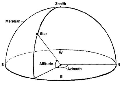
Consider the sky, as if it were the inside of a solid, hollow sphere. An observer dependent i.e. local coordinate system for the sky has an axis defined by the points directly overhead and underfoot of the observer. The overhead point is the zenith and the point exactly under the observer is nadir.
The equator of the coordinate system is the great circle that slices exactly between the zenith and nadir, corresponding to the observer's horizon. Altitude is measured in degrees above the horizon, so that the zenith is at 90º altitude, while the horizon is 0º altitude. Azimuth is measured on a parallel to the horizon, in degrees East from North, like the markings on a compass: 90º is due East, 180º is due South, and 270º due West.
Stars rise in the east, reach their highest point, or culminate, on the vertical
North Zenith South(NZS), and set in the west. The vertical NZS is called
the meridian. North and south directions are defined as
the intersections of the meridian and the horizon.
Note : Since the horizontal coordinates are time and position dependent, they cannot be used, for instance, in star catalogues.
- Altitude - Azimuthal Coordinate System
- Equatorial Coordinate System
Consider the sky, as if it were the inside of a solid, hollow sphere. An observer dependent i.e. local coordinate system for the sky has an axis defined by the points directly overhead and underfoot of the observer. The overhead point is the zenith and the point exactly under the observer is nadir.
The equator of the coordinate system is the great circle that slices exactly between the zenith and nadir, corresponding to the observer's horizon. Altitude is measured in degrees above the horizon, so that the zenith is at 90º altitude, while the horizon is 0º altitude. Azimuth is measured on a parallel to the horizon, in degrees East from North, like the markings on a compass: 90º is due East, 180º is due South, and 270º due West.
Stars rise in the east, reach their highest point, or culminate, on the vertical
North Zenith South(NZS), and set in the west. The vertical NZS is called
the meridian. North and south directions are defined as
the intersections of the meridian and the horizon.
Note : Since the horizontal coordinates are time and position dependent, they cannot be used, for instance, in star catalogues.
Altitude Azimuth System
Altitude - Azimuthal System
Equatorial Coordinate System
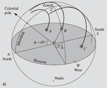
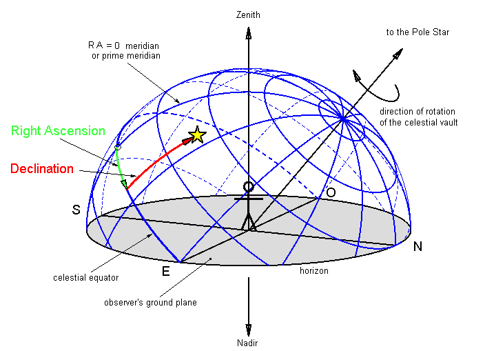
The direction of the rotation axis of the Earth remains almost constant and so does the equatorial plane perpendicular to this axis.
The equatorial system is the projection of Earth's coordinate system on the celestial sphere. The celestial equator is the projection of Earth's equator onto the sky, and the North and South celestial poles (NCP and SCP) are the points on the sky directly above Earth's North and South poles.
Instead of latitude, the North-South celestial coordinate is called Declination (Dec). As on the Earth, North-South positions are measured from the celestial equator, with the vertex at the Earth's center. Like latitude, it is measured in degrees, with negative values for positions South of the celestial equator. The equator is 0º Dec, and the South celestial pole is at -90º Dec. The East-West celestial coordinate is called Right Ascension (RA).
Note : Since declination and right ascension are independent of the position of the observer and the motions of the Earth, they can be used in star maps and catalogues.
Equatorial System
References :
https://dept.astro.lsa.umich.edu/ugactivities/Labs/coords/
Fundamental Astronomy 5th edition by Karttunen
https://dept.astro.lsa.umich.edu/ugactivities/Labs/coords/
Fundamental Astronomy 5th edition by Karttunen
